Friday, September 30, 2005

September Total

Total for this month: 173.6 miles

Cool and Foggy

This morning was a cool one, so I decided to take a little longer route into work. I don't have that many choices, since the river and the airport limit my approach. I started with a reverse of the return portion of the South Work Route. It was nice not feeling hot and sweaty when I arrived.


For the return trip, I followed the new North Route Extension. The best part was flying past all of the cars on Salisbury backed up for the light at Sagamore Parkway. I left around 5:20, and it was close to 6:30 before I arrived at home.

Electric Fence Post

Miles Ridden: 16.9

Thursday, September 29, 2005

Practice Time

All over campus, preparations are under way for the Notre Dame game this weekend. My rare after work ride took me by the band practice field, where the All American Marching Band was prepping for Saturday's show.

Purde All-American Marching Band Practice
Soon after, I came upon Ross-Ade Stadium, where crews were installing lights, food trucks were delivering concessions, and the groundskeepers were doing their thing. On the east side of the stadium, a marble crew was putting the finishing touches on the base for the new Boilermaker Statue.


Apparently, some anonymous donor commissioned an 18 foot tall bronze casting of an early 20th century iron worker. Now, the university is trying to figure out how to pay for the base and landscaping required to exhibit it.

As I headed towards the south part of campus, I noticed several tents being erected for weekend festivities. It's going to be a big day!

My route was basically a reverse River Road/Campus Route - with a little meandering around campus.

Miles Ridden: 10.4

Wednesday, September 28, 2005

Disaster Averted!

It's getting dark in the mornings. The neighbor and I headed out for the usual 6:00am ride, and headlights and blinky tail lights were in order. It's not too bad on the open country roads. Cars can see us. We can see them. Everyone's happy.

Unfortunately, it is a little difficult to see the smaller obstacles in the road. I narrowly missed rolling into a rather large dog pile in the bike lane (no photos). That would have splattered all over me and probably the neighbor behind me as well.

We basically took the Granville Bridge Route, but instead of riding onto the bridge, we rolled up to the entrance for Martel Forest. Coming back, we took River Road by the Gourd House.

It was our first ride on the recently finished bike lanes on Division and River Roads. Out in the country, it is very nice having a separate lane on a busy commuter road like that. There is a lot of traffic between 6:30 and 7:00 heading east - presumably to jobs on campus or in Lafayette. Thanks to the Tippecanoe County Highway Department and their contractors for a job well done.

Because of the darkness, I haven't been taking my camera along on rides. However, I saw a couple of neat sunrise shots on the way back that could have competed well in the Weather Picture of the Week contest. I'll bring it next time.

Miles Ridden: 11.5

Tuesday, September 27, 2005

This Fall on NBC - Bike Cops!

When the fall semester started this year, a curious thing happened. The bike rack at my building filled up. Now, this building is not a classroom building, nor is it a student residence hall, so one wouldn't expect a bunch of student bikes there. Plus, I'm the only one that rides to work (occasionally). Last year, mine was often the only bike in the rack. Now, I have to squeeze in.

I asked the building deputy where all of the bikes came from, and she told me that they were used by undercover police officers who cruise the campus as students. Apparently, they don't want to be seen riding to and from the police station, so they drive over to my place and start from there.

Dauch Bike Rack
I had a good ride to work today. The temperature was cool and there was little wind. Coming home, I started on the North Work Route, but instead of turning from Salisbury to Lindberg, I continued north to Kalberer Road. Turning west, I rode to the Cattail Trail and followed it south past the Evil Empire and the Lilly Nature Center at Celery Bog back to Lindberg. Lindberg, 400W, and Division Road brought me back home.

Miles Ridden: 15.5

Sunday, September 25, 2005

Feast

Feast of the Hunters' MoonNo rides this weekend, since I was helping my wife with her Feast of the Hunters' Moon booth. (I provide logistical support and don't dress in period garb.) Another task I have is to ferry family and friends who park in my driveway to and from the Fort.

I did take one ride to the Feast to visit the booth. There are no facilities for bikes at the park, so I had to chain the bike to a telephone pole along the road.

Miles Ridden: 2.3

Sharrows

The Christian Science monitor recently featured an article on "sharrows", a new bike marking that is intended to indicate that bikes and motor vehicles can share a lane.

Looks promising, but I can't imagine nearby towns using them. What do you think?

Sharrows

(Thanks to Cycledog)

Thursday, September 22, 2005

Crash!

I forgot to mention:

Last Thursday, I was walking across campus returning from a meeting, and I saw two bikes collide head on! They actually hit right in the middle of their front tires. Neither was going very fast, and while both came off the seats, they didn't fall down. One of the guys was just surprised, but the 2nd guy yelled at the first.

I watched it take place in what seemed like slow motion, and I couldn't believe that it happened. I think that there was some girl watching involved.

My colleague and I were cracking up and got dirty looks from the victims.

Green Canyon

I was out of town for a couple of days, so I was anxious to get back on the bike today. I wasn't able to ride to work, but I did put in a few miles before hand on the River Road/Campus Route.

As I was coming home on Newman Road, I noticed that the County crews had mowed recently. They use equipment that includes a mowing deck parallel to the ground to get the grass, and a vertical deck to 'trim' the bushes and limbs that are potruding into the right-of-way. Where the honeysuckle bushes are thick, the road looks like a 'Green Canyon' with high, green sidewalls. (I'll get a picture later and post it here.)

Green Canyon - Newman Road
Miles Ridden: 10.1

Saturday, September 17, 2005

Trouble Down Below

Sometimes even a bad ride is not so bad.

I was driving up to William Henry Harrison High School to drop my son there for a Marching Band trip to participate in a parade, so I decided to throw the bike in the van and start my ride from there. (I had to drive around to the other side of the building so my son's friends wouldn't see me in the bike shorts.)

Things could have gone better. I thought it would be neat to follow Charlie Meyer's Brookston Bakery route from his book, and I studied it before I left the house. I was almost to the school when I noticed that I hadn't brought the map with me. So, I decided to instead follow the 30 mile route from the recent Wabash River Century Ride, since the routes all started at the high school this year, and the markings were still easy to see. It would have been easier had I looked to see which color marking went with 30 mile route. I had no clue, so I decided to try the Brookston route by memory.

Interstate 65 Passes Under 100W in Tippecanoe County
I-65

I didn't do too badly, although a couple of problems marred the ride. I was over half a mile out when I noticed that the sensor for the odometer was not aligned with the magnet. (I rounded up half a mile in the final distance to compensate.) The seat was a bigger problem. I've been having trouble with it coming slightly loose and squeaking as I ride. Apparently, when I last adjusted it on Thursday, I set the horn up too high. By two miles in, my entire 'swimsuit area' was totally numb. I tried changing my position, but I finally just gave up and rode on in discomfort. (Man, I am such a whiner today!)

My memory of the route must have been OK, because I found Brookston without incident. I couldn't believe all of the garage sales that I saw - almost every other house. It was when I reached the highway that I realized why. This was the weekend for the Apple-Popcorn Festival.

Brookston Apple-Popcorn Festival
Apple-Popcorn Festival

It's kind of weird that they couldn't choose a single agricultural product harvest to celebrate in this little town, but I don't think they care. In addition to the endless lawns filled with used crap, there were two or three blocks of craft booths, non-profits selling snacks, and carnival entertainment. Someone was setting up a Strongman Game - where one hits a lever with a large hammer to try to ring the bell - as I rode to the convenience store.

I went in to get a drink and a square donut (as advertised above the door). Mine was more like a loose spiral. It was when I was in line to pay when the tingling started. Areas that had been deprived of blood flow for the last 30 minutes were being resupplied, and all of those little capilaries sprang back to life at the same time. Now that's invigorating!

As I left town, I ended up following the route of a something-K run. As the runners turned left, I continued south on the chip-and-seal road (100E). I noticed that it was turning into less seal and more chip. By the time I was a mile down the road at a 'T' intersection, my road and my two choices were all gravel. I turned west on what I later learned to be County Line Road, and went two miles in soft gravel - cursing and complaining the whole way. I was very happy to see pavement at 300E.

When I got to Springboro Road, another cyclist came by and asked directions. The only roads I knew were the gravel mess I left behind, and the path he had just traveled (Tyler Road towards Battleground), so I wasn't much help. We had a nice, short chat and each went on our way. Tyler Road soon crossed 900W and then met up with Pretty Prairie Road, so I was back on the Cairo Watchtower Route from May, at least for a short while.

Battleground Water Tower
Downtown Battleground, Indiana

I stopped in Battleground for a drink. I'm still wondering what 'Misting' is.

Battleground Misting Sign
The hill on Prophet's Rock Road that continues up 600N has to be the steepest I've ever climbed - maybe even worse than the uphill on 500W north of Division Road. I made it, but I was panting like crazy at the top. 600N took me back to County Farm Road and the high school. By that time, I was feeling pretty good.

Miles Ridden: 29.0

Thursday, September 15, 2005

Half a Ride

I had to take the van back to the shop today, so I tossed the bike in the back to take to work.

I love riding in the cool weather. I can get to the office without breaking a sweat.

Unfortunately, a fairly heavy rainstorm moved in just before 5:00. I called my wife and she picked me up on her way home.

Miles Ridden: Just 2.8

Tuesday, September 13, 2005

A Different Kind of Commute

The weather and my schedule cooperated today to allow me to ride to work. However, I changed the route a little, and changed my attitude as well.

Continuum - Purdue University
My recent rides in Madison have helped me better appreciate bike paths, so I tried the new one along part of State Street. It's only about a quarter mile long, but it does a good job of separating autos, pedestrians, and bikes. (There is still the problem of cars not expecting bikes to cross at every side street and driveway, so I had to at least slow down if not stop at each - a little bothersome.) After leaving the trail, I took Intramural Drive south to Harrison St. This leads to Grant street and the office. This route is slightly longer (not a problem) and much calmer. All of the traffic is on State Street, and I can usually feel the glaring eyes of the motorist 'trapped' behind me. In my mind, I'm having the argument about how bikers have the right to use the road and that sidewalks are for kids. I can get pretty worked up sometimes.

Sure, taking the path and longer route may be giving in, but I'll bet it helps my blood pressure.

Some of my change in attitude came from reading a series of essays on commuting and errand riding found on the Bicycling Life. I agreed with the Vehicular Cycling article, plus I liked the commuting stories. Give them a read sometime.

Continuum - Purdue University
For the ride home I took the South Work Route - even though I had to be home by 6:00. I decided that the extra 10 minutes would be worth the possible scolding at home. Turns out I made it within the deadline.

Miles Ridden: 10.7

Sunday, September 11, 2005

Otterbein

This morning was a foggy one, so the neighbor and I decided to avoid the Wabash River lowlands, and instead head northwest to Otterbein.

Like all of the best routes, we started by heading west on Division, and then up the hill on 400W. This leads to Jackson Highway, which we took northwest to Montmorenci.

350N travels west from Montmorenci to the county line and beyond. We turned north onto County Line Road, and it was just a few miles to Otterbein.

I had ridden there once before a couple of years ago, but it was the neighbor's first time there in any vehicle. The road became Main Street, which we followed up to the red flashing light in the center of the business district (only a few blocks in length) at the intersection of Oxford Road (which I think may be 'old US52').

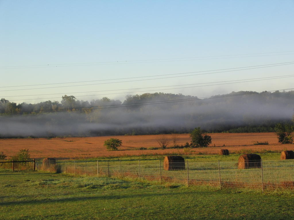
Wheeling east on Oxford Road, we passed the United Methodist Church, where I saw an old co-worker, Carol, walking in with her husband. We chatted for a couple of minutes until the organ fired up. After crossing US52, 500W took us east.

We started passing small test plots of crops that signaled the proximity of the Purdue Ag Research Farm. We decided to look for a southbound road that would put us back on 400W at US52. 425W was gravel, but 375W looked like a good bet. The south-southeast wind that had picked up provided a nice challenge. A couple of right angle turns lined us up with 400W perfectly. We crossed US52 for a second time at the Kelly Tires store.

Continuing south on 400W, we passed 250N (Fat Ass Road) and arrived back at the SR26/Lindberg Rd/ Jackson Highway intersection. There was a car that had plunged head first into the ditch being pulled out by an SUV driver with a tow strap. He easily saved $100 in tow truck charges.

It wasn't long before we were back home.

No pictures today, but after we left the familiar routes, the scenery was pretty flat. Browning fields and the occasional farm. It is kind of nice riding up on the prairie instead of in and out of the river valley all of the time.

Miles Ridden: 24.0 (Once around the cul-de-sac to roll it over)

Thursday, September 08, 2005

Work Ride - Day 3 of 3

Rain Out!

There was just enough rain at my house this morning to stop the ride.

Wednesday, September 07, 2005

Work Ride - Day 2 of 3

I started out a little late today because the neighbor had planned to ride in with me. However, his truck was already gone when I wheeled up his drive.

The ride in was uneventful, but I passed a co-worker of mine in the hall who asked if I was planning to attend the big 8:00 meeting. I had no idea it was even scheduled! I grabbed my file and hurried across campus to make it in time. Since I had no time to cool down after the ride, I was a big sweaty mess, and I'm sure I made quite an impression.

After work, I had to hurry home to take my son to a club meeting, so the route was direct there and back on Newman Road and SR26.

Miles ridden: 6.9

Tuesday, September 06, 2005

Work Ride - Day 1 of 3

It was an easy ride to work today, and the ride home on the South Work Route was relaxing and uneventful.

Miles Ridden: 8.6

Monday, September 05, 2005

Southside

Before my family moved west, we lived on the south side of Lafayette for 12 years. It was around the time that the 350S bypass was built and Poland Hill Road was upgraded that I started biking. I was driving through there the other day and thought it would be fun to ride the old routes.

Wabash River
Wabash River

I started today by taking River Road east to US231 and the Brannigan Bridge. Although it is a busy road, the "new" 231 is a fairly easy way to get across the river to the Shadeland/Elston area. There is a pretty wide shoulder, and I can block out the sound of the cars screaming past and just casually ride up the long hill. Today, however, I was pushing along when a car full of teens yelled like hillbillies as they passed. I was able to look cool and give a wave back, but I was actually scared shitless. The adrenaline was pumping like crazy, and my skin was covered in goosebumps. I think the little hairs on my back were standing up as well.

A fiberglss pig covered in astroturf

After cresting the hill and crossing SR25, I turned east onto 350S. The beginning section - between the "new" US231, across "old 231", and on to 9th street - is still a peaceful ride. However, as one continues east, much commercial development is encountered. There is a CVS drugstore where the old Four Square Christian Church (affectionately called the 'compound' by my wife and I) used to be. Plus, gas stations, restaurants, an ice cream store, a gym, and medical offices have popped up all over. Construction will start on the area's 3rd Wal-Mart at 350S and Concord soon. It is also expected that the state will take over the road as a new route for SR25. This is all in an area that was farm fields and gravel roads 10 years ago.

I took a short jaunt north on US52 (again ignoring the speeding traffic) to get to Ross Road and the Ivy Tech Lafayette campus. The campus was started when Tippecanoe County donated the Ross Sanitarium and the surrounding land to the school. The Sanitarium was built as a tuberculosis treatment center, and a conversion in the late 90's turned it into the school's administration building. I had my breakfast (PB&J sandwich) while sitting on a bench in the shade.

Ross Sanitarium - Ivy Tech Lafayette
Ross Sanitarium

From Ivy Tech, I headed east and north on Creasy Lane. This is another road that popped up in the 90's. It is said that the right lane in each direction is a little wider than the left to accommodate bicycle traffic. I think they are including the gutter that is peppered with big drain grates as the bike area, but I'm not riding there. I probably pissed off many drivers as I passed a car dealer, Sam's Club, Don Pablo's, Lowes, and a fire station. This is a busy commercial area.

At Greenbush Street, I turned west. The area between Creasy and US52 is under construction, but the rest of the distance was very calm. The northside is a working class neighborhood that has gone through a metamorphosis in the last few years. Neighborhood pride is high, and the residents keep things looking good, such as hanging plants on utility poles in the area.

A little ride up Ninth Street brought me to Canal Road. I took it south and jumped onto the Wabash River Heritage trail under the Harrison Bridge. This took me back to the train station at Riehle Plaza (where I'll be in the trombone section for tonight's season ending performance of the Lafayette Citizens' Band).

Riehle Plaza - Lafayette, IN
Riehle Plaza

I shot up State Street hill, through campus to Newman Road, back to Division and home.

Miles Ridden: 24.9

Sunday, September 04, 2005

It's Going To Be A Good Week


I think both the weather and my schedule will cooperate this week, so I will be able to ride to work three days! Plus, since Monday is a holiday, I can ride whenever.